


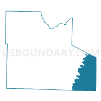
Nebo Voting District, Laclede County, Missouri
About
Outline

Summary
| Unique Area Identifier | 608908 |
| Name | Nebo Voting District |
| County | Laclede County |
| State | Missouri |
| Area (square miles) | 82.00 |
| Land Area (square miles) | 81.67 |
| Water Area (square miles) | 0.33 |
| % of Land Area | 99.59 |
| % of Water Area | 0.41 |
| Latitude of the Internal Point | 37.55018170 |
| Longtitude of the Internal Point | -92.30356790 |
Maps

Graphs
Select a template below for downloading or customizing gragh for Nebo Voting District, Laclede County, Missouri


Neighbors
Neighoring Voting District (by Name) Neighboring Voting District on the Map
- Competition Voting District, Laclede County, MO
- Gasconade Voting District, Laclede County, MO
- Laquey Voting District, Pulaski County, MO
- Manes Voting District, Wright County, MO
- Roubidoux No. 2 Voting District, Texas County, MO
- Upton No. 1 Voting District, Texas County, MO
Top 10 Neighboring County Subdivision (by Population) Neighboring County Subdivision on the Map
- Roubidoux township, Texas County, MO (1,819)
- Gasconade township, Laclede County, MO (905)
- Franklin township, Laclede County, MO (748)
- Upton township, Texas County, MO (592)
- Montgomery township, Wright County, MO (548)
- Roubidoux township, Pulaski County, MO (302)
Top 10 Neighboring Place (by Population) Neighboring Place on the Map
Top 10 Neighboring Elementary School District (by Population) Neighboring Elementary School District on the Map
Top 10 Neighboring Unified School District (by Population) Neighboring Unified School District on the Map
- Waynesville R-VI Schools, MO (36,404)
- Laquey R-V School District, MO (3,939)
- Plato R-V School District, MO (3,401)
Top 10 Neighboring State Legislative District Lower Chamber (by Population) Neighboring State Legislative District Lower Chamber on the Map
- State House District 148, MO (42,602)
- State House District 147, MO (38,962)
- State House District 146, MO (37,063)
- State House District 144, MO (35,226)
Top 10 Neighboring State Legislative District Upper Chamber (by Population) Neighboring State Legislative District Upper Chamber on the Map
Top 10 Neighboring 111th Congressional District (by Population) Neighboring 111th Congressional District on the Map
Top 10 Neighboring Census Tract (by Population) Neighboring Census Tract on the Map
- Census Tract 4801, Texas County, MO (7,828)
- Census Tract 4803, Texas County, MO (6,522)
- Census Tract 9602.98, Laclede County, MO (6,053)
- Census Tract 4705, Pulaski County, MO (5,754)
- Census Tract 4706, Pulaski County, MO (5,371)
- Census Tract 4901, Wright County, MO (3,820)
Top 10 Neighboring 5-Digit ZIP Code Tabulation Area (by Population) Neighboring 5-Digit ZIP Code Tabulation Area on the Map
- 65473, MO (15,059)
- 65711, MO (9,926)
- 65556, MO (5,869)
- 65552, MO (2,013)
- 65534, MO (1,029)
- 65470, MO (923)
- 65543, MO (431)